Monday, February 25, 2019

Days 28-31: Sturbridge at Last!

100 Worcester Rd to Sturbridge Coffee House
Today's report takes me seven miles through Charlton to Sturbridge, Massachusetts. My first goal is reached!

For the most part this trek took me past many businesses and some very old houses, most of which are not considered especially historical by realtors. For instance, there is this house (pictured below) at 19 Sturbridge Rd that was built in 1810. Quite beautiful, no? But not on any list of historical sites.
19 Sturbridge Rd, Charlton
And there is this house just off Highway 20 at 5 Carpenter Hill Rd in Charlton that was built in 1790.

5 Carpenter Hill Rd, Charlton
Massachusetts seems kind of blase about such old houses, unlike more recently settled states (such as Michigan).

Among the normal chain restaurants, industrial retailers, car dealerships, quick-stop stores and gas stations were a few businesses that caught my eye. One was Fabric Stash, a quilt store at 45 Sturbridge Rd, Charlton. It seemed like a typical quilt store, but it was nice to see it there as a local business.

Once I got into Sturbridge, I spotted Mole Hollow Candles. Though it sounds like an ordinary candle store, it's in fact not ordinary because they actually make the candles they sell there: Mole Hollow Candles, at 208 Charlton Rd, Sturbridge. And they make a lot of candles! Below is a photo of their building--yes, it's a factory.
Mole Hollow Candles
But lest you think they are like any other factory, I've copied the story of their beginnings from their website, below. I can picture these candle makers in 1969 selling their wares at farmers markets, can't you?
Mole Hollow Candles was founded in western Massachusetts in 1969. We began by selling candles at farmers markets, and slowly scaled up to a national presence. Today, Mole Hollow Candles can be found throughout the country at independent retailers, gourmet stores, Bloomingdale's, and Whole Foods Markets.

Quite a lot has changed since 1969, but some things - like our process and our materials - never will. We maintain the utmost commitment to quality, artisan manufacturing with a focus on domestically sourced waxes, wicks, and scents. We employ local craftspeople and all of our products remain made in Massachusetts.

Of course, passing through Sturbridge means passing by the famous historic site, Old Sturbridge Village, one of the many historic villages in the country, and the largest in New England. It's designed to recreate a village in 1830s Massachusetts. Since it is not located on US-20, I won't be visiting today, but I do have a memory of visiting it back in 1969 and enjoying it very much!

North Cemetery
The second oldest cemetery in Sturbridge, North Cemetery, lies along US-20, though you can't see it from the road.

Below is a plaque that was erected at the cemetery describing its historical significance.

North Cemetery Information
Well, I've finally made it to my destination today, the Sturbridge Coffee House, where I plan to take a break and have some coffee. It's a very appealing place!
Sturbridge Coffee House

Sturbridge Coffee House

Tuesday, February 12, 2019

Days 26 & 27: Heading for Charlton

The next two days and four miles take me into Charlton, Massachusetts. I'll be stopping at 100 Worcester Rd in Charlton, where there is a business called Innerenewal Massage & Integrated Therapy.
Arnies 24 Hr Towing to Innerenewal Massage Therapy
This stretch of road, much like the last few sections, hasn't much to distinguish it. But we are getting into some hillier terrain, as you can see from the terrain version of the Google map, below.

Charlton is an old town, as are the others along this route. It's fairly small--only about 13,000 people, most of whom are white with a median income of around $90,000. It was first settled in 1735 as a part of Oxford. It became its own town in 1775. It's famous for being the site of Grizzly Adams' grave, and for its library that notoriously banned one of Mark Twain's books, Eve's Diary, in 1906, as being indecent because of its illustrations: drawings of the unclothed Eve and her husband, Adam.

Unfortunately, US-20 does not pass through the historic districts of the town, but I shall continue on nonetheless, until I reach Sturbridge, which may proved more interesting. But for now, I'll rest at the site of Innerenewal Massage Therapy.
100 Worcester Rd, Charlton
On to the next stage of my journey and the next four hours of practice!

Tuesday, February 5, 2019

Days 24 & 25: Passing by Oxford

On this four-mile stretch I'm traveling from 530 Washington St, Auburn to Oxford, Massachusetts, stopping at Arnies 24 Hour Towing.

It looks like we have now reached the point where US-20 roughly parallels I-90 for a ways. This means the kinds of sights we will see along this stretch of the highway will be a continuation of the ones we've seen since arriving at Worcester: industrial wholesalers, car dealerships, major chain restaurants and hotels and big box stores such as Walmart and Home Depot. In other words, businesses are catering to people who are getting off the highway or just passing through. Residents also shop there, of course, but they want to keep their quaint towns quaint, so they don't encourage these kinds of businesses in the downtown areas. Auburn and Oxford's town centers are miles away from US-20 (Auburn north of the highway, Oxford south), which makes me wonder what was located here back in the day when the highway was the principal east-west route through the state.

One of the animals you can buy
 at  Dinky Reptiles
The one interesting, unusual and somewhat creepy business I passed is Dinky Reptiles and Aquatics, at 809 Southbridge Street, Auburn, where you can buy reptiles and amphibians and other slimy, slinky animals for pets, or sometimes for food (for your reptilian pets, apparently). Some people are into this sort of thing, and the store has gotten very good reviews, so who am I to say?

Oxford is also an old town, and has some interesting history. according to Wikipedia. Here is an excerpt from that article:
"Oxford was first settled in 1687 and was officially incorporated in 1713. It was the birthplace of Clara Barton, the first president and founder of the American Red Cross. Oxford was originally settled by Huguenots in two waves, the original settlement having been abandoned after four residents (John Johnson and his three children, Peter, Andrew and Mary) were killed in a violent confrontation with local Native Americans. This event, the Johnson Massacre, is commemorated near the south end of town on Main Street. The remains of the Huguenot Fort (built in 1686) still exist near Huguenot Road.[1]"
Well, I guess that's it for this leg of my journey. I've arrived at Arnie's 24 Hour Towing, so it's time to take a break.
Arnies 24 Hour Towing

Thursday, January 31, 2019

Days 22 & 23: Passing Through Auburn

For the next two days, I'm still traveling in a southwesterly direction, skirting the center of another town, this time Auburn.
505 US 20 to 503 Washington St, Auburn
Auburn is a town that was settled in 1714, as a part of several towns in the surrounding area. It was incorporated in 1778. It currently has about 16,000 citizens. It is known for being the place where Robert Goddard, according to Wikipedia, "launched the first liquid-fueled rocket from Pakachoag Hill, on his aunt Effe Ward's farm, in Auburn on March 16, 1926."

Once again, the area I'm traveling through seems rather undistinguished--industrial, commercial, and travel-oriented. I suspect that the exits off I-90 and I-290 that lead to US-20 have something to do with that. Plenty of lodging, food, and shopping along the way. There's even a mall not too far off the beaten path.

Well, I'm at my destination for this bit of my journey: 530 Washington St, although it's not a very good place to stop, since it's an apparently vacant house. Oh, well, I'll stop across the street at the Volkswagen/Saab dealership. They'll have a bathroom there, I think.
530 Washington St, Auburn
530 Washington St and Patrick Motors, across the street

Saturday, January 26, 2019

Days 20 & 21: Arriving at Worcester, Massachusetts

My next two days of two miles each take me at last to the first big town since leaving Boston: Worcester, Massachusetts. Below is a little bit of information about the city, taken from the Wikipedia article.
Named after Worcester, England, as of the 2010 Census the city's population was 181,045,[4] making it the second most populous cityin New England after Boston.[5] Worcester is located approximately 40 miles (64 km) west of Boston, 50 miles (80 km) east of Springfield and 40 miles (64 km) north of Providence. Due to its location in Central Massachusetts, Worcester is known as the "Heart of the Commonwealth", thus, a heart is the official symbol of the city. However, the heart symbol may also have its provenance in lore that the Valentine's Day card, although not invented in the city, was mass-produced and popularized by Esther Howland who resided in Worcester.[6]
I start my journey at Brody's diner, continuing along US-20 slightly more than four miles (to make up for the slightly less-than-four-mile journey of the day before) to a little house along US-20, 505 Southwest Cutoff. (Note: In the below map, I had to tell Google my trek was by auto because it wouldn't let me go directly there by US-20, for some unknown reason.)
Brody's Diner, Shrewsbury to 505 Southwest Cutoff, Worcester

Worcester has a lot of history to explore, and you can read about that in many places on the internet, including Wikipedia. But since I'm traveling around the city, I'm going to talk more about what I see along US-20.

One of the first features I pass is the rather long, thin lake called Quinsigamond by the Nipmuc people who inhabited the Worcester area prior to the arrival of English people. The below map of the lake was drawn in 1898.
The word in Algonquian means "pickerel (or long nose) fishing place." When the English settlers first arrived in the area, they got along with the Nipmuc--for a while, at least, even establishing a "praying town" in the Worcester area. Eventually, it became clear that the English were going to take all their land for little or no compensation, so they joined King Philip's War and ultimately lost most of their people and had to live on reservations in Worcester county. You can read about their fate in Wikipedia: Qunsigamond.

Once past the lake area, I leave Shrewsbury and enter Worcester, though it's the southern edge of the city. I'm walking through a mostly industrial area here, passing by small businesses, for the most part, some of them of longstanding duration in the area. One such business, S.I. Howard Glass Company, has been making, modifying and distributing specialty glass virtually since the company began, back in 1912. It's a small company, with only about 50 employees, and headed by a woman.

Walking along I see more businesses, many of them related to vehicles of one kind or another: cars, trucks, tractor-trailers. There are car and truck rentals and sales dealers, as well as parts and other types of support services. There is even an office of the Teamster's Union, Health and Welfare Fund at 330 SW Cutoff.

Finally I arrive at my stopping point for today: 505 Hwy 20, Worcester. It looks like a house that's been there a while, maybe back when US-20 was still a main route across the state.
505 US Hwy 20

Monday, January 21, 2019

Days 18 & 19: Traveling through Shrewsbury

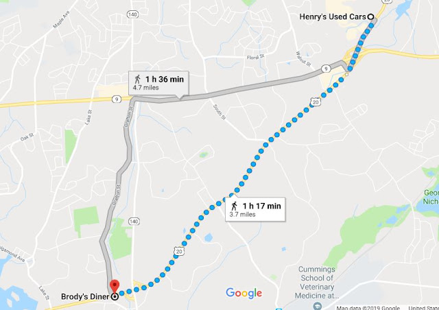
The next four-mile stretch takes me from Northborough into Shrewsbury. US-20 takes a southwesterly dip through the outskirts of this town, about three miles south of the town's center. I left from Henry's Auto Parts two days earlier and stopped at Brody's Diner, at 308 Hartford Turnpike in Shrewsbury.
Henry's Auto Parts to Brody's Diner in Shrewsbury
Along the way I encountered quite a bit of commerce, but not much to distinguish Shrewsbury from any other American town. Most of the historical sites are located on Main Street, north of US-20.

As with the towns I've visited previously, Shrewsbury is also an old town, having been parceled out in the mid-1660s, as were the other towns along this route. It was settled in 1722 and incorporated in 1727. It started out agricultural with apple orchards, then later turned to leather manufacture and clock making. It claims a bit of fame in its association with Shay's Rebellion in 1786--it was used as a camp site for rebels before they marched on the Worcester Courthouse. One famous resident was a scientist, Min Chueh Chang, who co-developed the combined oral contraceptive pill and helped create in-vitro fertilization. Another important individual from Shrewsbury is a candy maker who brought white chocolate to the U.S. in 1954, Frederick Hebert, who owned Hebert Candies, a store that has been in business since 1917, though is no longer family owned.

I did see an interesting institution, however: Al-Hamra Academy, located at 435 South St, very close to US-20. This school purports to be the first full-time Islamic school in New England. It's website is attractive, emphasizes STEM education and diversity, and makes the school seem like a good place to send your children if you're Muslim.

Well, I've arrived at Brody's Diner, a restaurant that was briefly famous for having been visited by Jerry Seinfeld as part of his program, Comedians in Cars Getting Coffee, in 2014. It looks like a good place, so I think I'll stop in for a bite to eat. More miles and more hours of practice coming up!
Brody's Diner

Saturday, January 19, 2019

Day 16 & 17: Discovering Historical Northborough

Today's journey takes me from Britney's Cafe in Northborough to Henry's Used Autos, four miles down US-20. I stopped at that business because it's the closest to the four-mile mark, although in that same vicinity is a mall with some familiar stores such as T.J. Maxx and Dick's Sporting Goods. I figure I can always hike up there if I need to once I get to Henry's.

Along the way I passed a number of historical buildings. The ones that stood out for me were a former church, a residence, and a former bank building. The first, at 97 Main Street, is the former home of an early resident, Samuel Wood. Below is a description of this building, taken from the website, Northborough's History: A Map Depiction, and a current photo.
97 Main St
"Samuel Wood, who left Sudbury to establish a mill on the Assabet River next to his new home, built the house at 97 Main Street in 1749. In addition to running a successful mill Wood was active in town politics, serving for eight years each on the precinct committee, as the town clerk, and as the town assessor. Wood also became a captain in the local militia before his death in 1760. Wood’s sons, Samuel Jr. and Abraham, expanded on their father’s business, opening a store called Clothier’s Mill Shop. Samuel Jr. became captain of the local militia, and was wounded at the Battle of Bunker Hill in 1775. The house was later owned by Thomas Blair, a businessman and inventor, who made several renovations, including the construction of a miniature door 20 feet to the west of the house (which has been mistakenly thought of to be a part of the Underground Railroad) that allowed coal to be delivered straight to the cellar."
Another interesting building, at 52 Main Street, was the Northborough Baptist Church that now houses the Northborough Historical Society. At one time it had a steeple, but that was torn off by the New England Hurricane of 1938. 
After the hurricane
52 Main Street today
That was a category 3 hurricane that swept through New England in September of 1938, with winds gusting to 186 miles per hour. I'd never heard of this hurricane, but apparently it caused great loss of life and tremendous damage. You can read the Wikipedia article on it: 1938 New England Hurricane and see the YouTube video, right------->.

28 Main Street
28 Main Street today
Another interesting building I saw on my way was a little ornate building at 28 Main Street that was built in 1854 to be a bank, back when banks were producing their own currency. It still looks pretty much as it did when the photo at left was taken, probably around 1900. Notice it says "BANK" on the front.

Well, I guess I'm at my destination: Henry's Used Cars. So, until next time, I'm keeping on with my practice and with my walk through Massachusetts. See you in the next town!
Henry's Used Cars

Friday, January 18, 2019

Day 14 & 15: More Fun in Marlborough

For the next two days I'm walking four miles on my journey, passing through the western part of Marlborough and on into the next town along US-20, Northborough.
Marlboro House of Pizza to Britney's Cafe in Northborough
The road is bit straighter leaving town, especially once I cross over I-495. As you might expect, there are quite a few hotels in this vicinity, as well as other businesses travelers like to see at interstate exits. What they might miss at that exit, however, is Williams Lake, a natural lake that was the site of settlement in the seventeenth century, not long after the town of Marlborough was first settled.

Something else travelers might miss near Williams Lake is an unobtrusive historical marker in front of what is now a small strip mall housing a popular sandwich shop, DeAngelo's Grilled Sandwiches. Once it was the location of the oldest operating tavern in the country, Williams' Tavern. Below is a slide (#19) from "The Old Homesteads of Marlborough," detailing the historical significance of this site.
Here is a photo of the marker; it's not in good shape, but it's been there since 1930.
from Waymarking.com
According to Wikipedia, Northborough was originally settled by Nipmuc people, then was part of a resettlement of the Sudbury Plantation in 1656. In 1766 it was established as part of Westborough; it was incorporated as its own town in 1775, just in time for the Revolution. Northborough is a small town--only about 6,000 people resided there in 2010 (according to City Data). The median annual household income was around $97,000 in 2016 and the population was about 93% white. Two well-known people are associated with the town: Mark Fidrych  of the Detroit Tigers was born there, and Daniel Wesson of Smith and Wesson fame started his career there as an apprentice to his brother Edwin.

I'm looking forward to seeing what historical sites there are in the downtown area, coming up next! Meanwhile, I think I'll tarry a while at Britney's Cafe, at 291 Main Street in Northborough.

Tuesday, January 15, 2019

Day 13: The Heart of Marlborough

Today's walk takes me from the fire barn east of town into the heart of downtown, though on US-20 I'm bypassing central Main Street. As you can see from the below map, US-20 takes a kind of looping path through the town of Marlborough.
Marlborough Fire Station 3 to Marlboro House of Pizza
One of the first features I notice in my walk is a nice park off to the right, Ghiloni Park, also part of a state forest, which has a number of hiking and nature trails as well as the usual park features such as a ball diamond and playground equipment. Below is a photo someone took of one of the nature trails.
Ghiloni Park
taken by Joshua B
An interesting piece of Marlborough history is close to my route: Spring Hill Cemetery, located at High Street, just off US-20. Find-a-Grave has a little write-up on this very old graveyard:
"In spite of its proximity to the Spring Hill Meeting House, which was not sited nearby until 1806, the Spring Hill Cemetery predates the church by nearly 150 years. It is the oldest of the many burial grounds in Marlborough, commonly understood to have been established at the time the town was founded in 1660. Unfortunately, any early town records of the laying out of the first burial ground have been lost. Local historians, noting the fact that the location of the cemetery a half-mile away from the first meeting house was somewhat unusual for a New England town, have speculated that the settlers cautiously placed it some distance from the "Indian Planting Field." They had, in fact, built their original meeting house on a corner of that land, angering the native people, to whom the planting field had been granted by the government. 
"The earliest graves here were apparently unmarked, or had wooden markers. The first marked with a stone was that of Capt. Edward Hutchinson, who died in August of 1675 as a result of wounds received in the ambush near Brookfield during King Philip's War. He was not a native of Marlborough, but was brought here after he was shot, and died several days later. The cemetery sits on 2.62 acres. The earliest (marked) death date is 1675 and latest ca. 1909. There are approximately 700 headstones."
Spring Hill Cemetery
I'm glad it's on the map, because otherwise I would not find it; it seems hidden away behind houses and trees.

One last historical note of interest: Marlborough has the bell that was at Harper's Ferry on that fateful day of John Brown's raid. It's called John Brown's Bell, and it's housed in a little stone building on Main Street, just off where US-20 and Main Street part ways. There's a long history which you can read if you care to at the Marlborough Historical Society site: John Brown's Bell. It also tells the origin of the Civil War Monument that stands in the center of town, honoring the 91 citizens of Marlborough who died in that war.  I can see it before me as I come to the end of my two-mile journey and take a break at the Marlboro House of Pizza. It's quite a grand statue, as is the rather ornate looking Baptist church that it stands near. You can see both off to the left at the top of the below photo, and in the close up, below that.


Sunday, January 13, 2019

Day 12: Exploring Marlborough

Walking through Marlborough will take two days; the first gets me almost to the center of town, ending at the Fire Department Station 3 at 260 Boston Post Road.
1119 Boston Post Rd, Sudbury to Fire Station 3 in Marlborough
The road is getting a bit more curvy now since we're getting a little bit more into the hilly area of Massachusetts, heading for the Appalachian Mountains. Below is a map that shows the terrain of the town. You can see there is quite a number of hills.
Terrain of Marlborough, MA
Marlborough has much more commerce than the other towns I've passed through since leaving Boston. In fact, it seems to me more like a "normal" town in that it has a number of ordinary features such as a Target store, an auto salvage yard, a Home Depot, Dollar Tree, Staples, quite a few restaurants and little stores, a strip mall, apartment complexes and even a couple of mobile home parks--and all right on US-20. This could be a town in Michigan if it weren't for the high cost of living here: 135 vs 100 for US average (per City Data), though it seems a little lower than the towns earlier on my route--income not quite as high ($77,000), population not quite as white (68%).

One of the businesses I encountered fairly soon in my walk is the headquarters for a railroad: the Grafton and Upton Railroad Company. This is a smallish, privately owned railroad that has been in operation since 1874 to serve the towns of Grafton and Upton (not far from Marlborough) and other surrounding areas. It was part freight, part passenger over the years and has changed ownership a few times. The most recent owner has rejuvenated the railroad, fixing the tracks and doing other refurbishments that were no doubt needed.

Of course, like most railroads these days, it's strictly a freight operation. And its main services seem to be transloading (i.e. transferring shipments from one mode of transportation to another, such as train to truck) and warehousing, bulk transfer and transfer of propane. The propane transfer has become controversial because the people of the towns the railroad passes through are worried about the safety of such hazardous chemicals. The railroad did not have to apply for permits for its operation, apparently due to laws that were enacted a while ago that exempted railroads from such regulatory restrictions. There is an interesting article in an online publication that talks about this controversy with respect to Grafton and Upton: Railroad Bullies.

Well, I guess that's enough for today's discoveries. I've reached my destination: the Fire Barn. (Maybe they'll let me use their bathroom.) Tomorrow I'll continue to see what can be seen in Marlborough.
Marlborough Fire Department Station 3


Friday, January 11, 2019

Day 11: Heading for Marlborough

Well, I've walked 20 miles so far, from the New England Conservatory of Music to Acapulcos in Sudbury. The next two miles takes me to the border of Sudbury and Marlborough, the next 17th-century town on US-20/Boston Post Rd. This part of Sudbury is less commercial and has more farms and wooded areas.
Acapulcos to 1119 Boston Post Rd, Sudbury
As I walk along I pass Wayside Inn Road that leads to one of the fun sites in Sudbury: Longfellow's Wayside Inn, a business that has been operating since 1716. (Click on the link to go to the website and learn all about this interesting place.) It's a historic site as well as a tavern and bed-and-breakfast hotel. It looks like a fun place to visit or stay, though I don't have time today to make the detour. But here is a look at the Inn:
Longfellow's Wayside Inn
photo by Frank C. Grace
Henry Wadsworth Longfellow visited the inn (then known as Howe's Tavern) with his publisher in 1862, a visit that prompted the author to write a book about it, Tales of a Wayside Inn, which resulted in making the Inn much more popular than it had been before.

Another Henry, Henry Ford, owned the property from 1923 to 1945. He created the "village" concept there--where there are a number of buildings brought together to make a "living" museum such that visitors will feel they are in that time period. The concept has been used in many historical sites over the years, but Longfellow's Wayside Inn was the first of its kind in the country, predating even Greenfield Village and Colonial Williamsburg.

Also off the beaten path in Sudbury is a related site: Ford's Folly. Now part of a hiking trail, this would-be dam was constructed by Ford to provide a reservoir to his historical village for fire-fighting purposes. Read about this interesting mistake at the Atlas Obscura website.

Well, I've reached the border of Sudbury and Marlborough where there is a pleasant-looking farm with cows off to the left. This ends my journey (and my two hours of practice) for today.
1119 Boston Post Road

Thursday, January 10, 2019

Day 10: Spending Time in Sudbury

For today's two-mile walk I'll be passing through the center of Sudbury, stopping eventually at a Mexican restaurant called Acapulcos.
King Philip Road to Acapulcos
This stretch of Sudbury is replete with commerce--stores, restaurants, medical facilities, an interior decorator and an auto service station. But I also pass by the town hall and the fire department. One of the more interesting buildings is the public library, the Goodnow Library, named after the resident who willed the land and money to build and stock the library, John Goodnow II. He died in 1851. The library was completed in 1853. The building is quite distinctive, as you can see (photo below); it has been listed on the National Register of Historic Places, as have a number of the town's buildings.
Goodnow Library
According to the website City Data, Sudbury is a small town of around 18,000 people. They are mostly white, college-educated, middle-aged, employed, and of English/Irish ancestry. The income level is fairly high: $185,000 median annual household income. House prices average around $800,000.

Well, I've come to my stopping point now, the Mexican restaurant, Acapulcos, at 694 Boston Post Road in Sudbury. Tomorrow I'll do another two miles and another two hours of practice. Hasta la vista!


Wednesday, January 9, 2019

Day 9: Heading for Sudbury

Today's two-mile trek takes me from The Local, in Wayland, to Sudbury, at a residence located at the corner of King Philip's Road and US-20.
The Local, Wayland, to Sudbury
Along the way, I cross over the Sudbury River, a name the town of Sudbury shares, and pass by many businesses located along the Boston Post Road/US-20. This is quite a bit different from the mostly residential stretch of road that was Weston.

Sudbury River at Wayland
The Sudbury River is an interesting river in that it flows northeast from Westborough to Concord, from an elevation of 327 feet down to 100 feet. For more information, see the Wikipedia article: Sudbury River. It's apparently a scenic river in spots, and provides recreational opportunities such as canoeing and kayaking.

Sudbury was established around the same time as Weston and Wayland, in 1638. As I mentioned in the post about Wayland, the town split into the two sections, West and East, in 1780. But in the 1630s, there was mainly wilderness beyond the western and northern borders of the town. According to a Sudbury history website, the original settlers were on good terms with the local indigenous people.
Sudbury Fight Marker
That must have changed in the decades following, as Sudbury was one of the towns involved in King Philip's War. "The Sudbury Fight," as it came to be called, was on April 21, 1676. At right is a photo of the sign that marks the spot near where the fighting took place.

You can read an interesting account of Sudbury's part in King Philip's War in this blog: Things Have Changed. Below is an excerpt:
"The Sudbury Fight was a tactical victory for King Philip's warriors. They had successfully conducted three ambushes - on Cowell and Wadsworth's commands as well as on the Concord men, and destroyed much of Sudbury west of the river. Fifty two militia were dead, while Indian losses may have been as few as four to six. Why the withdrawal occurred remains unknown, but King Philip never resumed the offensive, the initiative quickly moved to the colonials, and the war was over by the end of the year."
So that's why I thought the house at  #4 King Philip Road would be a good stopping place. It was built in 1729 and is currently occupied. I couldn't find a picture of it, but you can get a glimpse of the house from the Google Street View photo, below.
4 King Philip Road
Well that's for this day's "walk" and two hours of practice. Tomorrow's journey will take me to some other interesting sights in Sudbury, I'm sure.