Tuesday, May 12, 2020

Days 39-45: Heading to Wilbraham, Massachusetts

This week I practiced for nine hours, so that takes me nine more miles down US 20, heading west. Starting at house on the corner of US 20 and Dunhamtown Rd in Monson, MA, I end at a cute little diner in Wilbraham, Massachusetts, called The Fabulous Fifties Diner, at 2650 Boston Road (US 20) where I'll take a break.


Meanwhile, however, there are some interesting sights along the route. Palmer is the first town I encounter on my trek, and I very quickly cross the Quaboag River, a 26-mile long river that flows from Brookfield to Three Rivers, MA. Below is a pic and some historical information, taken from Wikipedia

"The river receives its name from Quaboag Pond, an Indian name meaning "red-water" (place or pond). At one time, this pond was called Podunk Pond. Early industry started along the Quaboag River downstream from West Brookfield, where the river started a 300-foot (91 m) change in elevation, providing significant waterpower. Major heavy industry was located in Warren, Massachusetts, because of the available waterpower from the river. Many of the dams on the river, used to provide waterpower, were destroyed during floods and not repaired or replaced. Parts of them remain, providing a hint of the river’s industrial past."

These days, the river is known as a good place for kayak paddling and fly fishing. This fun video, Quaboag River at 4 Ft, shows the videographer enjoying some paddling when the water was low, with some nice jazz music accompanying.

Palmer was first settled in 1716 by a man named John King, who came from England. He settled on the banks of the Quaboag River. Throughout the 18th century Palmer's name changed a few times, for a while being called Kingsfield after the town's first resident. The name Palmer came from a Chief Justice. The town was incorporated in 1775. It had a population of 12,140 in 2010, according to the census of that year. One of Palmer's claims to fame is its railroad depot, Union Station, designed by a famous architect, Henry Hobson Richardson, and its grounds were designed by Frederick Law Olmstead, who designed Central Park.

Passing through Palmer, I pass a number of businesses familiar along US highways: gas stations, taverns, strip malls, cafes, fast-food restaurants, retailers of various kinds, and industrial parks. One such park in Palmer is the Mapletree Industrial Center. Two businesses there are somewhat interesting; one is Iberia Foods, which distributes ethnic foods of various kinds to wholesalers and independent retailers throughout the US. The other is Australian Natural Soap, which imports and distributes fancy soaps from Australia.

Moving along, I come at last to Wilbraham, a town that was named after a couple of very old towns in England. It was first settled in 1740, but before that was a part of a tract purchased in 1636 from the Nipmuc by William Pynchon, who founded Springfield, of which Wilbraham is now considered a suburb. More information about the town can be found in this Wikipedia article: Wilbraham. We are obviously in the Appalachian foothills. Below is a topographical map that shows the elevation of the Wilbraham Mountains, a group of hills of varying heights surrounding US 20 at about the center of town. The red dot marks the location of the Taproom Bar and Grill, a bar and eatery on US 20. To the northeast you can see I-90 angling through, roughly paralleling the highway.
Taken from TopoZone
Well, I'm about at my destination now, so I'll stop and take a break. The Fabulous 50s Diner is not open for dine-in service right now because of Covid-19, but I can order take-out and enjoy it sitting on the little stone wall in front.
Fabulous Fifties Diner in Wilbraham, MA
 See you next week!

Saturday, May 2, 2020

Days 32-38: Heading to 2 Dunhamtown Rd, Monson, MA

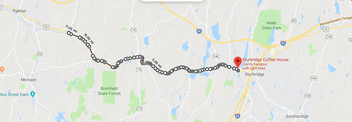
Well, it's been a while since I recorded my progress, so I decided that instead of trying to catch up, I'll just start from where I left off in February and go from there. This week I achieved several goals. so I get to "walk" 11.05 miles down Hwy 20. That takes me to a house at 2 Dunhamtown Rd in Monson, Massachusetts.
Sturbridge Coffee House to Monson, MA
Very soon after leaving Sturbridge I cross a lake/reservoir, East Brimfield Lake, in Fiskdale. This lake, created by a dammed river, is managed by the U.S. Army Corps of Engineers. One of its recreational features is the Quinebaug River Canoe Trail, which is a flat water canoe route with lots of scenic beauty and wildlife to view.
Quinebaug River Canoe Trail
Further along, I soon come to Brimfield, a town just west of East Brimfield and Fiskdale. Brimfield is nicely set up for tourists, it seems, especially those who like outdoor recreation. Plus they have a very nice old house, built around 1800, that currently serves as a bed and breakfast, the Elias Carter House Bed and Breakfast, with quite reasonable rates. They also have many antique shops and an annual antiques festival that brings lots of people into town.

Heading out of Brimfield for the next town west, Palmer, we are now getting into some serious hills. Take a look at the terrain map to get an idea of what I mean.

There are the usual businesses I've been seeing along this highway, but once in a while one catches my eye. For instance, in the town of Brimfield at 197 Palmer Road is Bryan's Pellet Stove Service, which advertises cleaning and repair of pellet stoves and furnaces, something one doesn't see too much outside of New England. Because there is less natural gas heating available in this region, people sometimes opt for more economical alternatives to heating oil--one of which is wood pellets.

The town of Monson, MA has the Quaboag River as its northern border, including a snippet that crosses US 20 where I end my trek for this week. The center of the town lies about 3.5 miles SW as the crow flies. Monson was settled briefly in 1657, but was abandoned due to Indian attacks and then permanently settled in 1715 as part of Brimfield; it became its own town in 1775. They were known for woolen mills and granite quarries. One claim to fame that the town has is that it suffered a tornado in 2011 that did some damage and killed three people. Very unusual for New England!

Well, I've reached my destination, so I guess I'll see if the folks in this residence will let me sit on their porch for a while and drink some water, eat a granola bar, and ponder the age of this house, built in 1825. As I've said before, Massachusetts seems pretty blase about their elderly houses. I guess 1825 is new to them, despite its being almost 200 years old!
Intersection of Dunhamtown Rd and US 20, Monson, MA


Monday, February 25, 2019

Days 28-31: Sturbridge at Last!

100 Worcester Rd to Sturbridge Coffee House
Today's report takes me seven miles through Charlton to Sturbridge, Massachusetts. My first goal is reached!

For the most part this trek took me past many businesses and some very old houses, most of which are not considered especially historical by realtors. For instance, there is this house (pictured below) at 19 Sturbridge Rd that was built in 1810. Quite beautiful, no? But not on any list of historical sites.
19 Sturbridge Rd, Charlton
And there is this house just off Highway 20 at 5 Carpenter Hill Rd in Charlton that was built in 1790.

5 Carpenter Hill Rd, Charlton
Massachusetts seems kind of blase about such old houses, unlike more recently settled states (such as Michigan).

Among the normal chain restaurants, industrial retailers, car dealerships, quick-stop stores and gas stations were a few businesses that caught my eye. One was Fabric Stash, a quilt store at 45 Sturbridge Rd, Charlton. It seemed like a typical quilt store, but it was nice to see it there as a local business.

Once I got into Sturbridge, I spotted Mole Hollow Candles. Though it sounds like an ordinary candle store, it's in fact not ordinary because they actually make the candles they sell there: Mole Hollow Candles, at 208 Charlton Rd, Sturbridge. And they make a lot of candles! Below is a photo of their building--yes, it's a factory.
Mole Hollow Candles
But lest you think they are like any other factory, I've copied the story of their beginnings from their website, below. I can picture these candle makers in 1969 selling their wares at farmers markets, can't you?
Mole Hollow Candles was founded in western Massachusetts in 1969. We began by selling candles at farmers markets, and slowly scaled up to a national presence. Today, Mole Hollow Candles can be found throughout the country at independent retailers, gourmet stores, Bloomingdale's, and Whole Foods Markets.

Quite a lot has changed since 1969, but some things - like our process and our materials - never will. We maintain the utmost commitment to quality, artisan manufacturing with a focus on domestically sourced waxes, wicks, and scents. We employ local craftspeople and all of our products remain made in Massachusetts.

Of course, passing through Sturbridge means passing by the famous historic site, Old Sturbridge Village, one of the many historic villages in the country, and the largest in New England. It's designed to recreate a village in 1830s Massachusetts. Since it is not located on US-20, I won't be visiting today, but I do have a memory of visiting it back in 1969 and enjoying it very much!

North Cemetery
The second oldest cemetery in Sturbridge, North Cemetery, lies along US-20, though you can't see it from the road.

Below is a plaque that was erected at the cemetery describing its historical significance.

North Cemetery Information
Well, I've finally made it to my destination today, the Sturbridge Coffee House, where I plan to take a break and have some coffee. It's a very appealing place!
Sturbridge Coffee House

Sturbridge Coffee House

Tuesday, February 12, 2019

Days 26 & 27: Heading for Charlton

The next two days and four miles take me into Charlton, Massachusetts. I'll be stopping at 100 Worcester Rd in Charlton, where there is a business called Innerenewal Massage & Integrated Therapy.
Arnies 24 Hr Towing to Innerenewal Massage Therapy
This stretch of road, much like the last few sections, hasn't much to distinguish it. But we are getting into some hillier terrain, as you can see from the terrain version of the Google map, below.

Charlton is an old town, as are the others along this route. It's fairly small--only about 13,000 people, most of whom are white with a median income of around $90,000. It was first settled in 1735 as a part of Oxford. It became its own town in 1775. It's famous for being the site of Grizzly Adams' grave, and for its library that notoriously banned one of Mark Twain's books, Eve's Diary, in 1906, as being indecent because of its illustrations: drawings of the unclothed Eve and her husband, Adam.

Unfortunately, US-20 does not pass through the historic districts of the town, but I shall continue on nonetheless, until I reach Sturbridge, which may proved more interesting. But for now, I'll rest at the site of Innerenewal Massage Therapy.
100 Worcester Rd, Charlton
On to the next stage of my journey and the next four hours of practice!

Tuesday, February 5, 2019

Days 24 & 25: Passing by Oxford

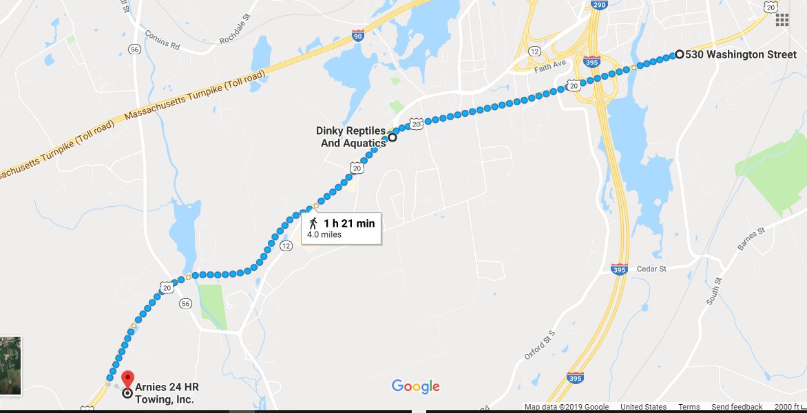
On this four-mile stretch I'm traveling from 530 Washington St, Auburn to Oxford, Massachusetts, stopping at Arnies 24 Hour Towing.

It looks like we have now reached the point where US-20 roughly parallels I-90 for a ways. This means the kinds of sights we will see along this stretch of the highway will be a continuation of the ones we've seen since arriving at Worcester: industrial wholesalers, car dealerships, major chain restaurants and hotels and big box stores such as Walmart and Home Depot. In other words, businesses are catering to people who are getting off the highway or just passing through. Residents also shop there, of course, but they want to keep their quaint towns quaint, so they don't encourage these kinds of businesses in the downtown areas. Auburn and Oxford's town centers are miles away from US-20 (Auburn north of the highway, Oxford south), which makes me wonder what was located here back in the day when the highway was the principal east-west route through the state.

One of the animals you can buy
 at  Dinky Reptiles
The one interesting, unusual and somewhat creepy business I passed is Dinky Reptiles and Aquatics, at 809 Southbridge Street, Auburn, where you can buy reptiles and amphibians and other slimy, slinky animals for pets, or sometimes for food (for your reptilian pets, apparently). Some people are into this sort of thing, and the store has gotten very good reviews, so who am I to say?

Oxford is also an old town, and has some interesting history. according to Wikipedia. Here is an excerpt from that article:
"Oxford was first settled in 1687 and was officially incorporated in 1713. It was the birthplace of Clara Barton, the first president and founder of the American Red Cross. Oxford was originally settled by Huguenots in two waves, the original settlement having been abandoned after four residents (John Johnson and his three children, Peter, Andrew and Mary) were killed in a violent confrontation with local Native Americans. This event, the Johnson Massacre, is commemorated near the south end of town on Main Street. The remains of the Huguenot Fort (built in 1686) still exist near Huguenot Road.[1]"
Well, I guess that's it for this leg of my journey. I've arrived at Arnie's 24 Hour Towing, so it's time to take a break.
Arnies 24 Hour Towing

Thursday, January 31, 2019

Days 22 & 23: Passing Through Auburn

For the next two days, I'm still traveling in a southwesterly direction, skirting the center of another town, this time Auburn.
505 US 20 to 503 Washington St, Auburn
Auburn is a town that was settled in 1714, as a part of several towns in the surrounding area. It was incorporated in 1778. It currently has about 16,000 citizens. It is known for being the place where Robert Goddard, according to Wikipedia, "launched the first liquid-fueled rocket from Pakachoag Hill, on his aunt Effe Ward's farm, in Auburn on March 16, 1926."

Once again, the area I'm traveling through seems rather undistinguished--industrial, commercial, and travel-oriented. I suspect that the exits off I-90 and I-290 that lead to US-20 have something to do with that. Plenty of lodging, food, and shopping along the way. There's even a mall not too far off the beaten path.

Well, I'm at my destination for this bit of my journey: 530 Washington St, although it's not a very good place to stop, since it's an apparently vacant house. Oh, well, I'll stop across the street at the Volkswagen/Saab dealership. They'll have a bathroom there, I think.
530 Washington St, Auburn
530 Washington St and Patrick Motors, across the street

Saturday, January 26, 2019

Days 20 & 21: Arriving at Worcester, Massachusetts

My next two days of two miles each take me at last to the first big town since leaving Boston: Worcester, Massachusetts. Below is a little bit of information about the city, taken from the Wikipedia article.
Named after Worcester, England, as of the 2010 Census the city's population was 181,045,[4] making it the second most populous cityin New England after Boston.[5] Worcester is located approximately 40 miles (64 km) west of Boston, 50 miles (80 km) east of Springfield and 40 miles (64 km) north of Providence. Due to its location in Central Massachusetts, Worcester is known as the "Heart of the Commonwealth", thus, a heart is the official symbol of the city. However, the heart symbol may also have its provenance in lore that the Valentine's Day card, although not invented in the city, was mass-produced and popularized by Esther Howland who resided in Worcester.[6]
I start my journey at Brody's diner, continuing along US-20 slightly more than four miles (to make up for the slightly less-than-four-mile journey of the day before) to a little house along US-20, 505 Southwest Cutoff. (Note: In the below map, I had to tell Google my trek was by auto because it wouldn't let me go directly there by US-20, for some unknown reason.)
Brody's Diner, Shrewsbury to 505 Southwest Cutoff, Worcester

Worcester has a lot of history to explore, and you can read about that in many places on the internet, including Wikipedia. But since I'm traveling around the city, I'm going to talk more about what I see along US-20.

One of the first features I pass is the rather long, thin lake called Quinsigamond by the Nipmuc people who inhabited the Worcester area prior to the arrival of English people. The below map of the lake was drawn in 1898.
The word in Algonquian means "pickerel (or long nose) fishing place." When the English settlers first arrived in the area, they got along with the Nipmuc--for a while, at least, even establishing a "praying town" in the Worcester area. Eventually, it became clear that the English were going to take all their land for little or no compensation, so they joined King Philip's War and ultimately lost most of their people and had to live on reservations in Worcester county. You can read about their fate in Wikipedia: Qunsigamond.

Once past the lake area, I leave Shrewsbury and enter Worcester, though it's the southern edge of the city. I'm walking through a mostly industrial area here, passing by small businesses, for the most part, some of them of longstanding duration in the area. One such business, S.I. Howard Glass Company, has been making, modifying and distributing specialty glass virtually since the company began, back in 1912. It's a small company, with only about 50 employees, and headed by a woman.

Walking along I see more businesses, many of them related to vehicles of one kind or another: cars, trucks, tractor-trailers. There are car and truck rentals and sales dealers, as well as parts and other types of support services. There is even an office of the Teamster's Union, Health and Welfare Fund at 330 SW Cutoff.

Finally I arrive at my stopping point for today: 505 Hwy 20, Worcester. It looks like a house that's been there a while, maybe back when US-20 was still a main route across the state.
505 US Hwy 20